The Ring of Fire
Spatial Scale: Planetary
Temporal Scale: 1017 Years
Mexico is situated in a unique geographic region where the movements of five different tectonic plates interact: the North American Plate, the Pacific Plate, the Rivera Plate, the Cocos Plate, and the Caribbean Plate. The telluric forces created due to the collisions, subductions and frictions of these plates are also part of the planetary-scale seismic area known as the Pacific Ring of Fire, of which New Zealand, Australia, Indonesia, the Philippines, Japan, Canada, the United States, Central America, Colombia, Peru, Ecuador and Chile also are part of, and where 80% of global seismic activity is observed.
Below is a spatial timeline which shows the registry of over 1000 years of seismic registry, showing seismic events of magnitudes larger than M6.0. A magnitude of an earthquake refers to the amount of energy released by the event.[3]
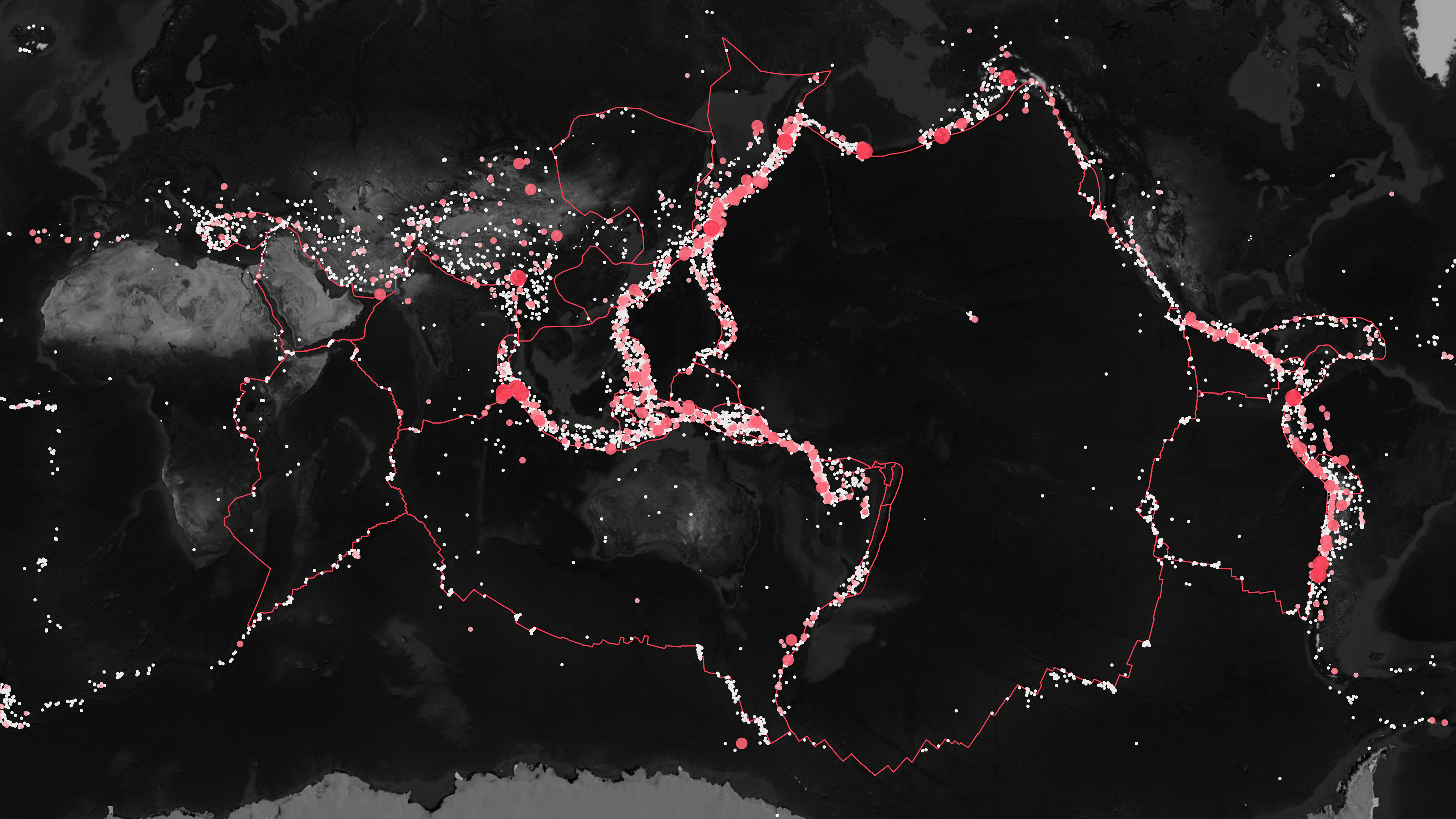
Click on the image to access an interactive map pf the Ring of Fire
58 Years of Seismicity in Mexico
Spatial Scale: Tectonic-National
Temporal Scale: 172 Years in Mexico + 58 Years in AO286
AO286's construction began in 1959 and ended in 1961, and stood until it collapsed on 19/09/2017. Below is a spatial timeline which shows all seismic events of M5.0 or higher that have been registered since 1845 by the Mexican Seismological Service (SSN). Additionally, throughout the 58 years it stood, the building withheld 20 earthquakes magnitudes higher than M5.0, some of them, like the 19/09/1985 and 07/09/2017 earthquakes, were of magnitudes stronger than the M7.1 earthquake that caused its structure to fail and fall. [4]
You may access an interactive map showing earthquakes from 1959-2017 here.
What these graphs show is that Mexico City, where AO286 is located, is a region in which seismicity is an enduring phenomenon. Both vulnerability and resilience to seismic forces has been constructed over time, as spaces of human inhabitation have developed, and created new conditions, as this platform explores in the next sections.
Explore the next force, Desiccation:

Database
You may download the editable map layers as SHP files here.
Bibliography:
[3] Suárez, Gerardo et al. “Seismic Historical Catalogue 1000-1903.” Global Quake Model. Accessed July 22, 2020. https://storage.globalquakemodel.org/what/seismic-hazard/historical-catalogue/.
[4]“SSN Catálogo de Sismos UNAM, México.” Accessed April 11, 2020. DOI 10.21766/SSNMX/EC/MX http://www2.ssn.unam.mx:8080/catalogo/#.
Bekaert, D. P. S., A. Hooper, and T. J. Wright. “Reassessing the 2006 Guerrero Slow‐slip Event, Mexico: Implications for Large Earthquakes in the Guerrero Gap.” Journal of Geophysical Research: Solid Earth 120, no. 2 (February 2015): 1357–75. https://doi.org/10.1002/2014JB011557.
Kerr, R. A. “Awaiting the Next Mexico City Earthquake: All Eyes Are on the Guerrero Seismic Gap off Mexico Where the next Great Earthquake to Shake Mexico City May Be Building.” Science 237, no. 4819 (September 4, 1987): 1118–1118. https://doi.org/10.1126/science.237.4819.1118.
Melgar, Diego, Xyoli Pérez-Campos, Leonardo Ramirez-Guzman, Zack Spica, Victor Hugo Espíndola, William C. Hammond, and Enrique Cabral-Cano. “Bend Faulting at the Edge of a Flat Slab: The 2017 M7.1 Puebla-Morelos, Mexico Earthquake.” Geophysical Research Letters 45, no. 6 (March 28, 2018): 2633–41. https://doi.org/10.1002/2017GL076895.
Roeslin, Samuel, Quincy T. M. Ma, and Hugón Juárez García. “Damage Assessment on Buildings Following the 19th September 2017 Puebla, Mexico Earthquake.” Frontiers in Built Environment 4 (December 4, 2018): 72. https://doi.org/10.3389/fbuil.2018.00072.
Ruiz-García, Jorge. “Examination of the Vertical Earthquake Ground Motion Component during the September 19, 2017 (Mw = 7.1) Earthquake in Mexico City.” Soil Dynamics and Earthquake Engineering 110 (July 2018): 13–17. https://doi.org/10.1016/j.soildyn.2018.03.029.