The Desiccation of the Basin of Mexico
Spatial Scale: Regional
Temporal Scale: 500+ Years
Mexico City is located on an endorheic basin, which means it is a valley with no natural water outlets, and where it can only escape by evaporation. This map shows the transformation of the basin, once dominated by a system of lakes, to the colonial operations which controlled water to make it disappear.[5]
This has been possible to a complex and progressively expanding network of drainage infrastructures which evacuate excess water in Mexico City when it experiences events of heavy rain in an attempt to prevent flooding. Simultaneously, Mexico City authorities have created a water access problem, prompting an infrastructure comparative in scale to satisfy the water needs of its millions of inhabitants by pumping water from nearby basins and digging water wells to reach underground aquifers, sometimes reaching a couple kilometers in depth.[6]
The following animation aims to represent the extent of desiccation's effects in changing dramatically the hydrology of Mexico City.
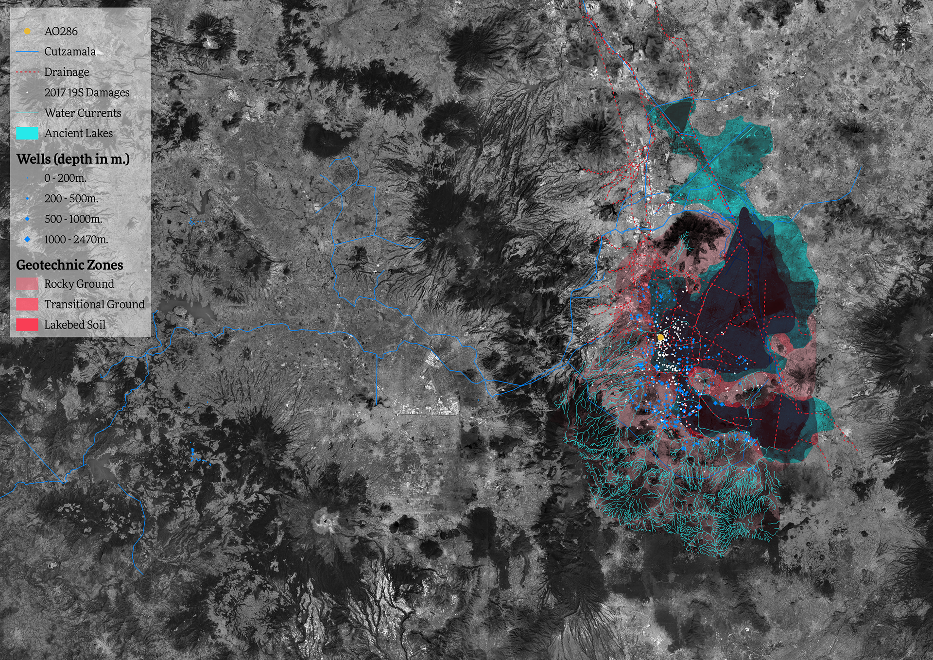
Click on the image to access an interactive map showing water infrastructure in Mexico City. AO286's position shown in yellow.
Subsidence
The ongoing practices of desiccation and aquifer exploitation causes Mexico City to progressively sink, a phenomenon called subsidence. From 1900 to 2000, Mexico City registered a subsidence of 12m. Subsidence occurs because Mexico City's soil is comprised of varying layers of porous volcanic composites and highly compressible clays. The desiccation process does not change the mechanical properties of some volcanic soils, but drastically transforms how clays behave.
As Mexico City's Government continues to expel water out of the Basin, these layers of clay dry out, become brittle, compress and break. This causes subsidence to happen irregularly, with differences of vertical displacements in meters occurring from one block to the next. Differential subsidence causes buildings to sink unequally, changing their vertical alignments. This process is also accelerated by overexploitation of underground aquifers.[7]
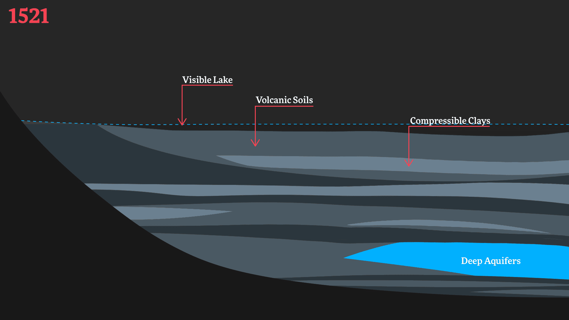
An animated representation of how the desiccation of the lakes and aquifer exploitation cause subsidence, change the volume of compressible soils, and creates differential settlements in built structures.
Changes in Seismic Response Spectra in AO286's Site
Spatial Scale: Site-specific
Temporal Scale: 60 Years
Although both processes, desiccation and sinking, have been observed for more than a century, widely understood as subsidence, their interactions with seismicity have only recently been established. The combined effects reveal how the environmental violence of water transformations in Mexico City change the mechanical properties of soil where buildings such as AO286 stand.
The following graphs show how the desiccation of Mexico City changes vulnerability to seismicity, indicating how desiccation, and aquifer exploitation transform a crucial aspect of seismic behaviour of the ground. The fundamental period of the soil upon which buildings were originally, and perhaps safely, calculated to withstand earthquakes, changes with subsidence. Potentially, a once compliant and safe structure becomes progressively vulnerable to future earthquakes. [8]
Ovando-Shelley et al, 2007.
Fundamental Period of Soil at AO286 site
Derived from the criminal case against the owners of AO286, a series of land surveys were performed on the 09/02/2018 to investigate the fundamental period of the soil at the site where AO286 stood. This study allows us to grasp the fundamental period of the soil at the site, or at which frequency the site resonates, and extrapolate from the observed and modeled changes in seismic response spectra how the soil at AO286 interacted with changes in desiccation.[9]
Buildings' structures are calculated and constructed to respond to a set of mechanical conditions at the time they are built. Through desiccation and subsidence, however, the mechanical properties and behaviour of the soil at sites like AO286 gradually change. This reveals that soil is not a static object, but rather an active agent which has fundamental interactions with how architectural structures behave.
Explore the next force, Regulation:

Database
You may consult a catalogue of geospatial data used for the cartographic animation here. Courtesy of Manuel Llano on behalf of CartoCrítica/Ciudadanía19S.
Bibliography:
[5] Candiani, Vera S. Dreaming of Dry Land: Environmental Transformation in Colonial Mexico City. Stanford, California: Stanford University Press, 2014.
[6] Lewis, Alan Christopher, and Janet Torres. “The Ghosts of Lake Texcoco Still Haunting Mexico City.” The Drop, Water Management and Hydrological Science Program, Texas A&M University, Volume 5, Fall 2013, September 15, 2013.
[7] Avilés, Javier, and Luis Eduardo Pérez-Rocha. “Regional Subsidence of Mexico City and Its Effects on Seismic Response.” Soil Dynamics and Earthquake Engineering 30, no. 10 (October 2010): 981–89. https://doi.org/10.1016/j.soildyn.2010.04.009.
[8] Ovando-Shelley, Efraín, Alexandra Ossa, and Miguel P. Romo. “The Sinking of Mexico City: Its Effects on Soil Properties and Seismic Response.” Soil Dynamics and Earthquake Engineering 27, no. 4 (April 2007): 333–43. https://doi.org/10.1016/j.soildyn.2006.08.005.
[9] Reinoso Ángulo, Eduardo. “Comparación Entre Espectros de Respuesta En La Estación Cibeles, Simulación En El Sitio Álvaro Obregón 286 y Espectros de Diseño Reglamentarios.” Evaluación de Riesgos Naturales, July 2018.
Castro, Raul. “Curvas de Gasto Medio Diario Del Gran Canal Del Desagüe En Las Temporadas de Aguas.” S/E. Mexico City: SAGARPA, 1931. Colección General. Mapoteca Manuel Orozco y Berra. http://w2.siap.sagarpa.gob.mx/mapoteca/mapas/10566-CGE-7251-A.jpg.
Filsinger, Tomás. “Atlas y Vistas de la Cuenca, Ciudad y Centro de México a Través de Los Siglos.” Ciudad de México, 2020.
Iglesias, José. “Plano Del Terreno Estudiado Por Huhuetoca Para El Desagüe Del Valle.” 1:40000. Mexico City: SAGARPA, 1986. Colección General. Mapoteca Manuel Orozco y Berra. http://w2.siap.sagarpa.gob.mx/mapoteca/mapas/2279-CGE-7251-A.jpg.
Salazar Ilarregui, José. “Plano Topográfico y Perfil de Los Acueductos Que Surten Agua a La Ciudad de México.” 1:30000. Mexico City: SAGARPA, 1860. Orozco y Berra. Mapoteca Manuel Orozco y Berra. http://w2.siap.sagarpa.gob.mx/mapoteca/mapas/240-OYB-725-C.jpg.
Salazar Ilarregui, José. “Plano Topográfico y Perfil de Los Acueductos Que Surten Agua a La Ciudad de México.” 1:30000. Mexico City: SAGARPA, 1860. Orozco y Berra. Mapoteca Manuel Orozco y Berra. http://w2.siap.sagarpa.gob.mx/mapoteca/mapas/240-OYB-725-C.jpg.
Velázquez, J.M., and A. Aldasoro. “Plano Del Lago de Texcoco Formado Por Miembro de La Comisión Del Desagüe y Limpia de La Ciudad de México.” 1:40000. Mexico City: SAGARPA, 1878. Colección General. Mapoteca Manuel Orozco y Berra. http://w2.siap.sagarpa.gob.mx/mapoteca/mapas/2444A-CGE-7251-B.jpg.
Vitz, Matthew. A City on a Lake: Urban Political Ecology and the Growth of Mexico City. Radical Perspectives. Durham: Duke University Press, 2018.